
Updated at 10:39 am and 10:55 am on August 29th to reflect the National Hurricane Center 11 am AST update.
By now, you should be hearing about Hurricane Dorian from meteorologists like me. I want to “cut to the chase “and say that the concern and “hype” for this storm is very much warranted. I mentioned something about “future Dorian” in a Forbes article exactly 7 days ago. It’s here and looks to be a significant threat to the U.S. mainland within the next 4 to 7 days. Here are four things that really worry me about Hurricane Dorian as we approach the weekend.
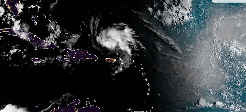
Hurricane Dorian on the morning of August 29th as daylight approaches the United States
NOAA/CIRA
It is expected to become a Major Hurricane. The United States has very recent and devastating experience with a major hurricane (category 3 or higher on the Saffir Simpson scale), Hurricane Michael. As we transition into the most active part of the Atlantic hurricane season, Dorian has cleared the Caribbean islands and has several days to strengthen as it approaches the Bahamas and then the U.S. mainland. According to the 5 am National Hurricane Center discussion on August 29th:
the global models show this shear diminishing within 12-24 hours. With lower shear and very warm waters, all of the intensity models forecast Dorian to begin strengthening again soon, and rapid intensification could occur…Dorian is likely to reach major hurricane strength in the next day or two and is forecast to maintain that status until it reaches land.
The graphic below illustrates that there is ample warm water and no major wind shear barriers ahead of Dorian’s path. The 11 am National Hurricane Center update increases the potential strength to category 4 (see cone below) and has landfall near the U.S. Space Coast.

Wind shear conditions and sea surface temperatures. Green to yellow lines indicate regions of wind shear more favorable for hurricane intensification.
CIMSS and NOAA
It is going to slow down. Another ominous statement in the National Hurricane Center discussion this morning is related to Dorian’s speed. The forecaster wrote, “The most notable change in the new forecast is that it’s a little bit slower than the previous one as Dorian approaches Florida.” Weather Channel senior hurricane expert Dr. Rick Knabb picked up on that trend in a Tweet last night. Knabb, also the former Director of the National Hurricane Center, tweeted:
One of the most concerning parts of the #Dorian track is how slow it gets near Florida. Storm surge and wind will likely be life-threatening, but let’s also prepare for an inland flood disaster somewhere in southeastern U.S. That hazard has taken the most lives in recent years.
If you look at the most recent cone forecast below, you can also see that there is not as much movement between 2 am Monday and 2 am Tuesday near the Florida coastline. You may recall that Hurricane Michael moved through the panhandle quickly. The primary hazards were wind and storm surge. I fear that Dorian will have those elements in addition to potentially flooding rainfall.
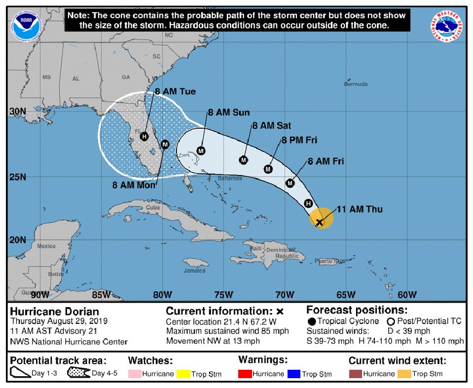
11 am AST on August 29th, 2019 National Hurricane Center update.
NOAA
Where it goes after landfall. I am also concerned about where Dorian goes after landfall. There is certainly a chance that the storm could drift into the Gulf of Mexico and produce a second landfall. The models showed that scenario yesterday. However, more recent runs of the American GFS model and the European model, take the storm up the Florida peninsula. The American model has the storm lingering into Georgia (my home state and also devastated by Hurricane Michael well inland). The European model takes the storm a bit more up the coast on its northward trajectory after landfall and maintains a more robust storm. Candidly, some model information also presents a scenario in which the storm doesn’t reach land and curves up the coast as we saw with Matthew a few years ago. These scenarios will depend on the strength of high pressure steering the storm and how much it slows down.
My key message is to use the models as “Guidance not Gospel” at this point. Try to avoid speaking in “absolute” terms about the ultimate landfall location or its intensity but understand that we certainly know enough for preparation and planning. The models will change in the coming days and likely converge to more consistent guidance (We hope). For now, the entire Florida and southeast coastal community should be on alert. Even if you live in the eastern Gulf Coast states, I wouldn’t completely take my eyes off of the storm yet.
The “expanding” bullseye. Professor Stephen Strader brings up an interesting point that also has me concerned. Strader, a professor of Geography, Atmospheric Sciences, and Hazards at Villanova University, is an expert on the relationship between vulnerable places and weather. He recently tweeted the image below and said:
Growing concern with #Dorian looking like it is strengthening and head towards #Florida. Substantial growth in population the built-environment exacerbates impacts and increased the odds of disaster. Prime example of Expanding Bull’s Eye Effect

The number of housing unites per hectare in Florida in 1950 and 2019
Stephen Strader on Twitter
Strader raises an interesting point about the amount of vulnerable infrastructure. There is also an implicit assumption that many of the people “in those structures” may not have experienced a landfalling major hurricane before.
There are many other things to be concerned about with Dorian including the very wet conditions that have already plagued south-central Florida in recent weeks. Will that amplify the flood threat and the possibility of even more falling trees. Will the soil moisture and Everglades help sustain a slowing or stalled hurricane over land (the so-called Brown Ocean Effect)? How will expected King Tides and other tidal activity affect storm surge and coastal flooding?
I am certainly watching Dorian closely from my meteorological “eye.” However, I do have a personal interest too. My daughter and I have tickets to the Florida State vs Boise State football game in Jacksonville on Saturday night. We’ll see what happens.